UNESCO is an international organisation whose aim is the promotion of education, science, culture, communication and information. It gives the title of World Heritage Site to places that qualify due to their uniqueness and authenticity. They also have a so-called Black List for those places that are threatened by grave danger.
Here are the first 11 beautiful places in the world you should visit as soon as possible:
Part 1/4 (status 12.03.15)
Index:
Old City of Jerusalem and its Walls (1982).01
Garamba National Park (1984).02
Chan Chan Archaeological Zone (1986).03
Air and Ténéré Natural Reserves (1992).04
Mount Nimba Strict Nature Reserve (1992).05
Everglades National Park (1993).06
Virunga National Park (1994).07
Río Plátano Biosphere Reserve (1996).08
Simien National Park (1996).09
Kahuzi-Biega National Park (1997).10
Manovo-Gounda St Floris National Park (1997).11
11 Beautiful places in the world that will be gone soon:
1. Old City of Jerusalem and its Walls (map)
 See more pictures of the Old City of Jerusalem here.
What is the Old City of Jerusalem? The Old City is a 0.9 square kilometers area within the modern city of Jerusalem. Until 1860 this area constituted the entire city of Jerusalem. The Old City is home to several sites of key religious importance: the Temple Mount and Western Wall for Jews, the Church of the Holy Sepulchre for Christians, and the Dome of the Rock and al-Aqsa Mosque for Muslims. Today, the Old City is roughly divided into the Muslim Quarter, the Christian Quarter, the Jewish Quarter and the Armenian Quarter.
Why was it added? Uncontrolled urban development, general deterioration of the state of conservation due to tourism and lack of maintenance.
2. Garamba National Park (map)
 See more pictures of the Garamba National Park here.
What is Garamba Park? Garamba National Park is one of Africa's oldest National parks. Garamba is (or at least was) the home to the world's last known wild population of Northern White Rhinoceros. The park is also well known for its African elephant domestication programme started in the 1960s, which managed to train tourist-rideable animals from the naturally wild beasts.
Why was it added? Reduction of Northern White Rhinoceros population (1984); poaching of two white rhinos, killing of three rangers and no plan for corrective measures by the authorities (1996)
3. Chan Chan Archaeological Zone (map)
 See more pictures of the Chan Chan Zone here.
What is the Chan Chan Zone? The largest Pre-Columbian city in South America, Chan Chan is an archaeological site in the Peruvian region of La Libertad. Chan Chan covers 20 km² and had a dense urban center of 6 km². Chan Chan was constructed by the Chimor, a late intermediate period civilisation. Chan Chan is the largest in the world and it was built around AD 850.
Why was it added? Natural erosion: the city's ruins are threatened by storms, earthquakes and looters.
4. Air and Ténéré Natural Reserves (map)

What are Air and Ténéré Reserves? The Aïr Mountains is a triangular massif, located in northern Niger, within the Sahara desert. They rise to more than 1,800 m (5,900 ft) and extend over 84,000 km2 supporting a wide variety of life. There are notable archaeological excavations in the region that illustrate the prehistoric past of this region. The Lycaon pictus dog once existed in this region, but may now be extirpated due to human population pressures in this region.
Why was it added? Military conflict and civil disturbance in the region as well as a reduction of wildlife population and degradation of the vegetation.
5. Mount Nimba Strict Nature Reserve (map)
 Picture by Guy Debonnet for UNESCO.. See more pictures of Mount Nimba Reserve here.
What is Mount Nimba Reserve? Mount Nimba Strict Nature Reserve is a protected area in both Guinea and Côte d'Ivoire. The park includes significant portions of Mount Nimba, a geographically unique area with more than 200 endemic species. These species include multiple types of duikers, big cats, civets, Chimpanzees, and several types of viviparous toads.
Why was it added? Iron ore mining concession on part of the World Heritage Site and influx of large number of refugees on the Guinean part of the site.
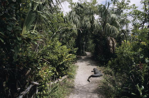
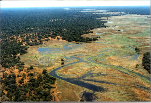
6. Everglades National Park (map)
 Picture by David Geldhof for UNESCO.. See more pictures of Everglades National Park here.
What is Everglades Park? Everglades National Park is a U.S. National Park in Florida. In the United States, it is the largest tropical wilderness and is visited on average by one million people each year. It is the third-largest national park in the lower 48 states after Death Valley and Yellowstone. Although most U.S. national parks preserve unique geographic features, Everglades National Park was the first created to protect a fragile ecosystem. The Park is the most significant breeding ground for tropical wading birds in North America, contains the largest mangrove ecosystem in the western hemisphere, is home to 36 threatened or protected species including the Florida panther, the American crocodile, and the West Indian manatee, and supports 350 species of birds, 300 species of fresh and saltwater fish, 40 species of mammals, and 50 species of reptiles.
Why was it added? Damage due to Hurricane Andrew and deterioration of water flow and quality due to agricultural and urban development (1993); continued degradation of the site resulting in a loss of marine habitat and decline in marine species (2010).
7. Virunga National Park (map)
 See more pictures of Virunga National Park here.
What is Virunga Park? The Virunga National Park, formerly named Albert National Park, is a 7,800-square-kilometre National Park in the eastern Democratic Republic of the Congo. The park was established in 1925 as Africa's first national park.
Why was it added? In recent years poaching and the Congo Civil War have seriously damaged its wildlife population.
8. Río Plátano Biosphere Reserve (map)
 See more pictures of the Reserve here.
What is Río Plátano Reserve? The Río Plátano Biosphere Reserve is 5,250 km² of preserved land in the La Mosquitia region on the Caribbean coast of Honduras. Most of the land runs along the Río Plátano. The reserve has a number of endangered species and some of Honduras largest sections of forest. The reserve encompasses both mountainous and lowland tropical rainforest, full of diverse wildlife and plant life, and has more than 2000 inhabitants.
Why was it added? Currently there are threats to the conservation of the reserve which include illegal hunting, logging and clearing of land to graze cattle. Recent rafting expeditions from the Rio Platano headwaters through all three zones of the reserve (cultural, buffer and core)have documented cattle grazing in the core zone,commercial fishing and hunting camps along the river and clear cutting of forest near Las Marias.
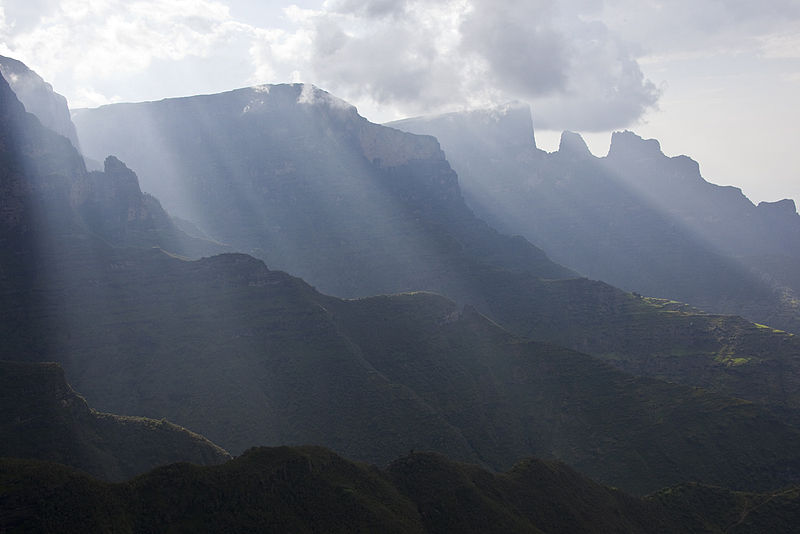
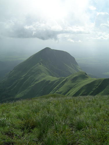
9. Simien National Park (map)
 View more images from the Simien Park here.
What is Simien Park? Simien Mountains National Park is one of the national parks of Ethiopia. Its territory covers the Simien Mountains and includes Ras Dashan, the highest point in Ethiopia. Semien Mountains It is home to a number of endangered species including a wild goat found nowhere else in the world. More than 50 species of birds inhabit the park. The park is crossed by an unpaved road.
Why was it added? Deterioration of population of Animals.
10. Kahuzi-Biega National Park (map)
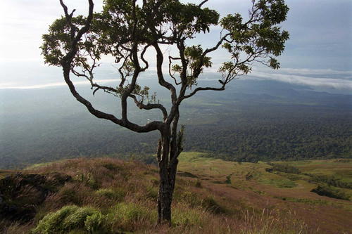 Photo by Gueney for UlutunçokLaif (GTZ).. You can see more pictures of Kahuzi-Biega Park by clicking here.
What is Kahuzi-Biega? The Kahuzi-Biega National Park is a protected area near Bukavu town in eastern Democratic Republic of the Congo. Established in 1970, the park is named after two dormant volcanoes, Mount Kahuzi and Mount Biega, which are within its limits. With an area of 6,000 square kilometres and set in both mountainous and lowland terrain, it is one of the last refuges of the rare species of Eastern lowland gorilla. The park is a UNESCO World Heritage Site, inscribed in 1980 for its unique biodiversity of rainforest habitat and its eastern lowland gorillas.
Why was it added? Deforestation, hunting as well as war and civil strife.
11. Manovo-Gounda St Floris National Park (map)
 Pic by José Tello.. See more photos from Manovo-Gounda here.
What is Manovo-Gounda? Manovo-Gounda St. Floris National Park is a national park near the Chad border. It was inscribed to the list of World Heritage Sites in 1988 as a result of the diversity of life present within it. Notable species include black rhinoceroses, elephants, cheetahs, leopards, red-fronted gazelles, and buffalo; a wide range of waterfowl species also occurs in the northern floodplains.
Why was it added? The site is under threat due to its rare wildlife dying and animals species being wiped out. The site was added to the List of World Heritage in Danger after reports of illegal grazing and poaching by heavily armed hunters, who may have harvested as much as 80% of the park's wildlife. The shooting of four members of the park staff in early 1997 and a general state of deteriorating security brought all development projects and tourism to a halt.


Comments